
Saturday, 23 July 2016
Smog Stresses Skin Cells by KAINAT MUNIBA KHAN
Smog is nasty enough in the atmosphere, but now research suggests that ozone, a key component of smog, stresses out human skin cells.
Cars and factories belch pollutants into the air that combine with the sun's rays to form photochemical smog. Ozone in the lower atmosphere contributes to the smog that's visible to the eye; this is different from ozone high in the atmosphere that helps protect life on Earth from deadly doses of ultraviolet solar radiation.
Researchers at the University of Wisconsin, Madison, exposed human skin cells to the smog-related ozone in the laboratory and found that they turned on cellular machinery that normally responds to stress, suggesting ozone may be toxic to human skin. However, further experiments are required to confirm the findings in people.
Smog breaks down into free radicals when zapped by the sun. These free radicals bounce around inside cells like pinballs, destroying most of the "machinery" they hit. Free radical damage has been implicated in diseases such as cancer, heart disease, Alzheimer's disease and Parkinson's disease.
While smog's damaging effects on our respiratory system have been well studied, little is known about how smog affects our skin, even though urban and suburban residents are repeatedly exposed to ozone on smoggy days.
The lab research involved isolating and exposing normal skin cells to ozone at 0.3 parts per million. Typical ozone levels in big cities can range from 0.2 to 1.2 ppm.
In the lab, ozone exposure boosted the activity of enzymes that convert environmental pollutants and cigarette smoke to more toxic compounds.
Reference:The study was published in the June 18 issue of the Journal of Investigative Dermatology.
THANKS KAINAT MUNIBA KHAN

Monday, 11 July 2016
How will climate change affect rainfall? by KAINAT MUNIBA KHAN
Changes in rainfall and other forms of precipitation will be one of the most critical factors determining the overall impact of climate change. Rainfall is much more difficult to predict than temperature but there are some statements that scientists can make with confidence about the future.
A warmer atmosphere can hold more moisture, and globally water vapour increases by 7% for every degree centigrade of warming. How this will translate into changes in global precipitation is less clear cut but the total volume of precipitation is likely to increase by 1-2% per degree of warming.
There's evidence to show that regions that are already wet are likely to get wetter, but details on how much wetter and what impacts there will be on a local scale are more difficult to ascertain. The dry regions of the subtropics are likely to get drier and will shift towards the poles. For much of Europe, wetter winters are expected, but with drier summers over central and southern Europe.
It is the changes in weather patterns that make predicting rainfall particularly difficult. While different climate models are in broad agreement about future warming on a global scale, when it comes to predicting how these changes will impact weather – and consequently rainfall – there is less agreement at a detailed level.
It is likely that in a warmer climate heavy rainfall will increase and be produced by fewer more intense events. This could lead to longer dry spells and a higher risk of floods.
So far, any impact that climate change may have had generally on regional rainfall cannot be distinguished from natural variations. However, for some specific cases a signal is starting to emerge. A recent study showed that man-made climate change substantially increased the odds of damaging floods occurring in England and Wales in autumn 2000. For the UK, current understanding suggests that increases in heavy rainfall during winter may start to become discernible more generally in the 2020s.
Climate models and observations are improving all the time and the reliability of predictions is likely to improve significantly over the next few years. In particular, new satellites and more detailed models are opening up new possibilities for understanding and predicting how water cycles through the climate system.
For example, current climate models typically represent atmospheric processes only down to scales of about 50-100km. This limits their ability to incorporate the effects of mountains and coastlines and means that small-scale processes, such as convection, must be represented by average approximations. In addition, the latest regional climate models capture daily rainfall on large scales but are not good at capturing heavier or more localised events.
However, the latest generation of localised weather forecasting models represent scales down to 1km and can capture these localised features. Scientists are now starting to apply these models to climate change studies, raising the possibility of much more confidence in their predictions of changes in extreme rainfall.THANKS KAINAT MUNIBA KHAN
Sunday, 10 July 2016
The Introduction of Monsoon Season by KAINAT MUNIBA KHAN
The introduction of Monsoon season: ( تعارف مون سون )
The Arabic language word for the season 'mawsin' is the root of the word 'monsoon' due to their annual presence Although the exact cause of the monsoons is not fully conclude, no one expert debate that pressure of air is one of the primary factors.
In Every summer season, southern Asia especially India including Pakistan, Bangladesh, SriLanka & others , is soaked by heavy rain that's come from wettish air masses, that mosit air move in from the Indian Ocean to the southern areas. These showers, and the masses of air that bring them, are called as monsoons ( مون سون یا مانسون ).This term was used first in English language in British India (now this term use in India, Bangladesh and Pakistan) and other nearby countries.
What is the monsoon cycle ?
Monsoon is not only known as summer rain but as well as the complete cycle that consist of both in summer water-soaked on shore and also shower from the south offshore,In winter of Asia water-less or drought winds that's blow to the Indian Ocean.In summer season,Indian Ocean under over the high pressure (HP) area, while a low subsist over the Asia.
Development of Monsoon :
The high pressure over the ocean of air masses move from the to the low pressure over the Asian continent, produce moisture-laden air to south Asia.During winter season in Asia, the process is backtrack and a low pressure lies over the Indian Ocean while a high pressure sit over the Tibetan plateau so air flows directly down to the south ocean and Himalaya. The migration of swap winds and wind from the west also provide to the monsoons season.
When does Pakistan monsoon season start and end?
This a very good question for our PWF fans.Summer Monsoon rainy season occurs in South Asia including Pakistan from end of June to the month of October.The Thar Desert and adjoining areas of the upper and central parts of subcontinent heats up considerably during the hot summers season, which causes a low pressure area over the Upper and central parts of sub-continent.Some parts of the South Asian countries receive up to 80,000-10,000 mm of rain per year.
Importance of Monsoon Season:
The wet monsoons, which begins almost suddenly in June, are especially important to India,Pakistan, Bangladesh, and Myanmar (Burma). Monsoon rains are very important and responsible for Over 50% percent of Pakistan and 90% of Indian water supply. The rains usually last until September.
Affected area of Asia during Monsoon:
About world's half of the population including Pakistan especially India lives in the monsoons affected areas of the Asia and majority of all these people are existence farmers, so the coming monsoon and goings of the monsoon season are dynamic to their livelihood to grow food to feed themselves. Too much or two little shower from the monsoon season can become a disaster in the form of famine or flood.
World Wide Monsoon: ( عالمی مون سون )
The smallish monsoons also take place in northern Australia, equatorial Africa, and to a slight bound in the southwestern parts United States of America. THANKS KAINAT MUNIBA KHAN
Monday, 4 July 2016
Before, During, and After Flooding by KAINAT MUNIBA KHAN

Causes of Floods in Pakistan by KAINAT MUNIBA KHAN


Government failure in controlling floods in Pakistan by KAINAT MUNIBA KHAN
Flood Conditions in Pakistan
The government of Pakistan is expected to adopt a healthy strategy and functional plan to control the flooding situation in Pakistan. Despite much criticism and loss of so many precious lives over the years; we are still stuck with same old school methods and relief efforts.
As you are all aware that in the past few years, floods have caused much loss to the floodplains beside catastrophically affecting the livelihood of people due to improper management, lack of communication between responsible authorities and overall poor infrastructure; the flooding situation has gone beyond the limits of endurance.
After the year 2010, in which mega Indus river flood has caused a lot of destruction some major steps have been taken by the government to minimize the damage condition. Major help was provided by army soldiers (as expected) along with helicopters loaded with food and camping stuff. According to different studies conducted by the researchers, it is estimated that the intensity of floods in Pakistan will only increase in next coming years. Investigators and geoscientists also believe that if precautionary measures are not adopted right away; the situation of loss will become extensively worse. On an average, approximately 715,000 people in Pakistan are affected by the different floods each year; which causes an estimated loss of $2.7 billion to the country’s economy. Considering a developing country like Pakistan, where the economic and political situation is already so vulnerable; any type of economic issue can only make the situation worse. According to World’s Resources Institute; the expected loss of life may increase to up to 2.7 million per year by 2030 due to flooding alone.
Living with the Floods
According to some ministers of climate change, floods can cause major destruction if no intervention is adopted. For example, it is believed that controlling the situation with the protection of forests and country’s natural resource can reduce the damage and number of deaths and casualties significantly. Now Pakistan is developing its fourth national flood prevention program to manage the destructive causes in order to better prepare for future years.
Lessons from the Past
A cost-effective strategy to control the flood situation was planned in the year 2012. The major aim was to focus on restoration of flood wetland and use of water supply wisely. The planned strategy was highly convincing to manage the flood loss, but this strategy was failed to be implemented due to political influence. None of the politicians has shown interest in investment over this plan as they think that this will give them a personal disadvantage and monetary loss only. As the time passed some influential politicians have invested on the development of flood risk areas such as the development of electricity poles, roads, and permanent structures supporting the land to minimize the flood loss.
Help towards understanding flood disaster management can be taken from past incidences. A major example includes Yangtze river basin flood management plan which was developed in the year 1998, after the massive destruction of flood causing 4,000 deaths and an estimated loss of $25 billion.
Integrated approach
National flood protection plan
As discussed above a national plan is being developed by the National Engineering Services of Pakistan with the help of Netherlands, the plan is now ready to be implemented and will majorly focus on the areas of flood risk management such as forests up streaming, restoring of wetlands and mapping of floodplains. Implementation of this plan will provide a more holistic approach towards flood management.
River act
Another act drafted by the ministry which emphasizes on the construction and betterment of already identified and large reservoirs such as Diamer Basha, Chiniot and Kurram, Kalabagh etc. and upgrading the system of flood warning system
Implementation of new flood strategy
Federal flood commission of Pakistan is responsible for implementing the drafted strategies after reviewing them with the ministry. Federal food commission of Pakistan comprises of different members from provincial irrigation departments, environment protection agencies, water and power development authority, army forces etc. along with all these members there is a strong political influence that has made its impact as hindrance in implementation of such plans and strategies causing a serious failure in flood control.
However in presence of all the resources and progressive development measures the plan fails to be implemented, the only way to resolve and tackle the flood conditions in Pakistan is coordination and most importantly cooperation among the responsible authorities and government. THANKS KAINAT MUNIBA KHAN
Tuesday, 28 June 2016
How Climate Change Causes Earthquakes and Erupting Volcanoes by KAINAT MUNIBA KHAN
The idea that a changing climate can persuade the ground to shake, volcanoes to rumble, and tsunamis to crash on to unsuspecting coastlines seems, at first, to be bordering on the insane. How can what happens in the thin envelope of gas that shrouds and protects our world possibly influence the potentially earth-shattering processes that operate deep beneath the surface? The fact that it does reflects a failure of our imagination and a limited understanding of the manner in which the different physical components of our planet—the atmosphere, the oceans, and the solid earth, or geosphere—intertwine and interact.
If we think about climate change at all, most of us do so in a very simplistic way: the weather might get a bit warmer, floods and droughts may become more of a problem, and sea levels will slowly creep upwards. Evidence reveals, however, that our planet is an almost unimaginably complicated beast, which reacts to a dramatically changing climate in all manner of different ways, a few straightforward and predictable, some surprising, and others downright implausible. Into the latter category fall the manifold responses of the geosphere.
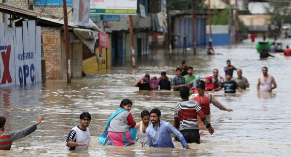
The world we inhabit has an outer rind that is extraordinarily sensitive to change. While the earth's crust may seem safe and secure, the geological calamities that happen with alarming regularity confirm that this is not the case. Here in the United Kingdom, we only have to go back a couple years to April 2010, when the word on everyone's lips was Eyjafjallajökull—the ice-covered Icelandic volcano that brought UK and European air traffic to a grinding halt. Less than a year ago, our planet's ability to shock and awe headed the news once again as the east coast of Japan was bludgeoned by a cataclysmic combination of megaquake and tsunami, resulting—at a quarter of a trillion dollars or so—in the biggest natural-catastrophe bill ever.
In the light of such events, it somehow seems appropriate to imagine the earth beneath our feet as a slumbering giant that tosses and turns periodically in response to various pokes and prods. Mostly, these are supplied by the stresses and strains associated with the eternal dance of a dozen or so rocky tectonic plates across the face of our world, a sedate waltz that proceeds at about the speed that fingernails grow. Changes in the environment too, however, have a key role to play in waking the giant, as growing numbers of geological studies targeting our post-ice-age world have disclosed.
Between about 20,000 and 5,000 years ago, our planet underwent an astonishing climatic transformation. Over the course of this period, it flipped from the frigid wasteland of deepest and darkest ice age to the—broadly speaking—balmy, temperate world upon which our civilization has developed and thrived. During this extraordinarily dynamic episode, as the immense ice sheets melted and colossal volumes of water were decanted back into the oceans, the pressures acting on the solid earth also underwent massive change. In response, the crust bounced and bent, rocking our planet with a resurgence in volcanic activity, a proliferation of seismic shocks and burgeoning giant landslides.
The most spectacular geological effects were reserved for high latitudes. Here, the crust across much of northern Europe and North America had been forced down by hundreds of meters and held at bay for tens of thousands of years beneath the weight of sheets of ice 20 times thicker than the height of the London Eye. As the ice dissipated in soaring temperatures, the crust popped back up like a coiled spring released, at the same time tearing open major faults and triggering great earthquakes in places where they are unheard of today. Even now, the crust underpinning those parts of Europe and North America formerly imprisoned beneath the great continental ice sheets continues to rise—albeit at a far more sedate rate.
As last year's events in Japan most ably demonstrated, when the ground shakes violently beneath the sea, a tsunami may not be far behind. These unstoppable walls of water are hardly a surprise when they happen within the so-called ring of fire that encompasses the Pacific basin, but in the more tectonically benign North Atlantic their manifestation could reasonably be regarded as a bit of a shock. Nonetheless, there is plenty of good, hard evidence that this was the case during post-glacial times. Trapped within the thick layers of peat that pass for soil on Shetland—the UK's northernmost outpost—are intrusions of sand that testify to the inland penetration of three tsunamis during the last 10,000 years.
Volcanic blasts too can be added to the portfolio of postglacial geological pandemonium, the warming climate being greeted by an unprecedented fiery outburst that wracked Iceland as its frozen carapace dwindled, and against which the recent ashy ejaculation from the island's most unpronounceable volcano pales.
The huge environmental changes that accompanied the rapid post-glacial warming of our world were not confined to the top and bottom of the planet. All that meltwater had to go somewhere, and as the ice sheets dwindled, so the oceans grew. An astounding 52 million cubic kilometers of water was sucked from the oceans to form the ice sheets, causing sea levels to plummet by about 130 meters—the height of the Wembley Stadium arch. As the ice sheets melted so this gigantic volume of water was returned, bending the crust around the margins of the ocean basins under the enormous added weight, and provoking volcanoes in the vicinity to erupt and faults to rupture, bringing geological mayhem to regions remote from the ice's polar fastnesses.
The breathtaking response of the geosphere as the great ice sheets crumbled might be considered as providing little more than an intriguing insight into the prehistoric workings of our world, were it not for the fact that our planet is once again in the throes an extraordinary climatic transformation—this time brought about by human activities. Clearly, the earth of the early 21st century bears little resemblance to the frozen world of 20,000 years ago. Today, there are no great continental ice sheets to dispose of, while the ocean basins are already pretty much topped up. On the other hand, climate change projections repeatedly support the thesis that global average temperatures could rise at least as rapidly in the course of the next century or so as during post-glacial times, reaching levels at high latitudes capable of driving catastrophic breakup of polar ice sheets as thick as those that once covered much of Europe and North America. Could it be then, that if we continue to allow greenhouse gas emissions to rise unchecked and fuel serious warming, our planet's crust will begin to toss and turn once again?
The signs are that this is already happening. In the detached US state of Alaska, where climate change has propelled temperatures upward by more than 3 degrees Celsius in the last half century, the glaciers are melting at a staggering rate, some losing up to 1 kilometer in thickness in the last 100 years. The reduction in weight on the crust beneath is allowing faults contained therein to slide more easily, promoting increased earthquake activity in recent decades. The permafrost that helps hold the state's mountain peaks together is also thawing rapidly, leading to a rise in the number of giant rock and ice avalanches. In fact, in mountainous areas around the world, landslide activity is on the up, a reaction both to a general ramping-up of global temperatures and to the increasingly frequent summer heat waves.
Whether or not Alaska proves to be the "canary in the cage"—the geological shenanigans there heralding far worse to come—depends largely upon the degree to which we are successful in reducing the ballooning greenhouse gas burden arising from our civilization's increasingly polluting activities, thereby keeping rising global temperatures to a couple of degrees centigrade at most. So far, it has to be said, there is little cause for optimism with emissions rocketing by almost 6 percent in 2010 when the world economy continued to bump along the bottom. Furthermore, the failure to make any real progress on emissions control at last December's Durban climate conference ensures that the outlook is bleak. Our response to accelerating climate change continues to be consistently asymmetric, in the sense that it is far below the level that the science says is needed if we are to have any chance of avoiding the all-pervasive devastating consequences.
So what—geologically speaking—can we look forward to if we continue to pump out greenhouse gases at the current hell-for-leather rate? With resulting global average temperatures likely to be several degrees higher by this century's end, we could almost certainly say an eventual goodbye to the Greenland ice sheet, and probably that covering West Antarctica too, committing us—ultimately—to a 10-meter or more hike in sea levels.
GPS measurements reveal that the crust beneath the Greenland ice sheet is already rebounding in response to rapid melting, providing the potential—according to researchers—for future earthquakes, as faults beneath the ice are relieved of their confining load. The possibility exists that these could trigger submarine landslides spawning tsunamis capable of threatening North Atlantic coastlines. Eastern Iceland is bouncing back too as its Vatnajökull ice cap fades away. When and if it vanishes entirely, new research predicts a lively response from the volcanoes currently residing beneath. A dramatic elevation in landslide activity would be inevitable in the Andes, Himalayas, European Alps, and elsewhere, as the ice and permafrost that sustains many mountain faces melts and thaws.
Across the world, as sea levels climb remorselessly, the load-related bending of the crust around the margins of the ocean basins might—in time—act to sufficiently "unclamp" coastal faults such as California's San Andreas, allowing them to move more easily, at the same time acting to squeeze magma out of susceptible volcanoes that are primed and ready to blow.
The bottom line is that through our climate-changing activities we are loading the dice in favor of escalating geological havoc at a time when we can most do without it. Unless there is a dramatic and completely unexpected turnaround in the way in which the human race manages itself and the planet, then long-term prospects for our civilization look increasingly grim. At a time when an additional 220,000 people are lining up at the global soup kitchen each and every night, when energy, water, and food resources are coming under ever-growing pressure, and when the debilitating effects of anthropogenic climate change are insinuating themselves increasingly into every nook and cranny of our world and our lives, the last thing we need is for the dozing subterranean giant to awaken. THANKS KAINAT MUNIBA KHAN
Subscribe to:
Posts (Atom)